All books / Book
Remote Sensing and Image Interpretation
| Full title: | Remote Sensing and Image Interpretation |
|---|---|
| ISBN: | 9781118343289 |
| ISBN 10: | 111834328X |
| Authors: | Lillesand, Thomas |
| Publisher: | Wiley |
| Edition: | 7 |
| Num. pages: | 736 |
| Binding: | Paperback |
| Language: | en |
| Published on: | 2015 |
Read the reviews and/or buy it on Amazon.com
![]()
Synopsis
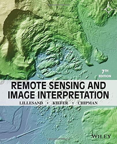
The Front Cover Shows A Topographic Image Derived From Airborne Lidar Data, Two Days After The Massive Oso Landslide (march 2014, In Washington State). With More Than Forty Deaths And Nearly Fifty Homes Destroyed, This Event Ranks Among The Deadliest Landslides In U.s. History, Lidar (light Detection And Ranging; Chapter 6) Is An Active Remote Sensing Technique That Involves Transmitting Pulses Of Laser Light Toward The Ground And Measuring The Elapsed Lime Of Pulse Returns. The Laser's Rapid Pulse Rate Yields A Dense Cloud Of Points That Can Be Analyzed To Extract The Shape Of The Ground Surfaces, As Well As Trees, Structures, And Other Objects. Analysis Of Lidar Images From Before And After The Event Shows That The Landslide Covered An Area Of Approximately 120 Hectares (300 Acres) And That About Four Million Cubic Meters (5.2 Mil Hon; Cubic Yards) Of Material Moved Downslope. Chapter 8, Section 8.14 (natural Disaster Assessment) Provides Additional Imagery And Discussion Of The Oso Landslide. Machine-generated Contents Note: 1.1. Introduction -- 1.2. Energy Sources And Radiation Principles -- 1.3. Energy Interactions In The Atmosphere -- 1.4. Energy Interactions With Earth Surface Features -- 1.5. Data Acquisition And Digital Image Concepts -- 1.6. Reference Data -- 1.7. The Global Positioning System And Other Global Navigation Satellite Systems -- 1.8. Characteristics Of Remote Sensing Systems -- 1.9. Successful Application Of Remote Sensing -- 1.10. Geographic Information Systems (gis) -- 1.11. Spatial Data Frameworks For Gis And Remote Sensing -- 1.12. Visual Image Interpretation -- 2.1. Introduction -- 2.2. Early History Of Aerial Photography -- 2.3. Photographic Basics -- 2.4. Film Photography -- 2.5. Digital Photography -- 2.6. Aerial Cameras -- 2.7. Spatial Resolution Of Camera Systems -- 2.8. Aerial Videography -- 2.9. Conclusion -- 3.1. Introduction -- 3.2. Basic Geometric Characteristics Of Aerial Photographs -- 3.3. Photographic Scale -- 3.4. Ground Coverage Of Aerial Photographs -- 3.5. Area Measurement -- 3.6. Relief Displacement Of Vertical Features -- 3.7. Image Parallax -- 3.8. Ground Control For Aerial Photography -- 3.9. Determining The Elements Of Exterior Orientation Of Aerial Photographs -- 3.10. Production Of Mapping Products From Aerial Photographs -- 3.11. Flight-planning -- 3.12. Conclusion -- 4.1. Introduction -- 4.2. Across-track Scanning -- 4.3. Along-track Scanning -- 4.4. Example Across-track Multispectral Scanner And Imagery -- 4.5. Example Along-track Multispectral Scanner And Imagery -- 4.6. Geometric Characteristics Of Across-track Scanner Imagery -- 4.7. Geometric Characteristics Of Along-track Scanner Imagery -- 4.8. Thermal Imaging -- 4.9. Thermal Radiation Principles -- 4.10. Interpreting Thermal Imagery -- 4.11^ Radiometric Calibration Of Thermal Images And Temperature Mapping -- 4.12. Flir Systems -- 4.13. Hyperspectral Sensing -- 4.14. Conclusion -- 5.1. Introduction -- 5.2. General Characteristics Of Satellite Remote Sensing Systems Operating In The Optical Spectrum -- 5.3. Moderate-resolution Systems -- 5.4. Landsat-1 To -7 -- 5.5. Landsat-8 -- 5.6. Future Landsat Missions And The Global Earth Observation System Of Systems -- 5.7. Spot-1 To -5 -- 5.8. Spot-6 And -7 -- 5.9. Evolution Of Other Moderate-resolution Systems -- 5.10. Moderate-resolution Systems Launched Prior To 1999 -- 5.11. Moderate-resolution Systems Launched Since 1999 -- 5.12. High-resolution Systems -- 5.13. Hyperspectral Satellite Systems -- 5.14. Meteorological Satellites Frequently Applied To Earth Surface Feature Observation -- 5.15. Noaa Poes Satellites -- 5.16. Jpss Satellites -- 5.17. Goes Satellites -- 5.18^ -- 4.11^ Ocean-monitoring Satellites -- 5.19. Earth-observing System -- 5.20. Space Station Remote-sensing -- 5.21. Space Debris -- 6.1. Introduction -- 6.2. Radar Development -- 6.3. Imaging Radar System Operation -- 6.4. Synthetic Aperture Radar -- 6.5. Geometric Characteristics Of Radar Imagery -- 6.6. Transmission Characteristics Of Radar Signals -- 6.7. Other Radar Image Characteristics -- 6.8. Radar Image Interpretation -- 6.9. Lnterferometric Radar -- 6.10. Radar Remote Sensing From Space -- 6.11. Seasat-1 And The Shuttle Imaging Radar Missions -- 6.12. Almaz-1 -- 6.13. Ers, Envisat, And Sentinel-1 -- 6.14. Jers-1, Alos, And Alos-2 -- 6.15. Radarsat -- 6.16. Terrasar-x, Tandem-x, And Paz -- 6.17. The Cosmo-skymed Constellation -- 6.18. Other High-resolution Spaceborne Radar Systems -- 6.19. Shuttle Radar Topography Mission -- 6.20. Spaceborne Radar System Summary -- 6.21. Radar Altimetry^^^ 6.22. Passive Microwave Sensing -- 6.23. Basic Principles Of Lidar -- 6.24. Lidar Data Analysis And Applications -- 6.25. Spaceborne Lidar -- 7.1. Introduction -- 7.2. Preprocessing Of Images -- 7.3. Image Enhancement -- 7.4. Contrast Manipulation -- 7.5. Spatial Feature Manipulation -- 7.6. Multi-image Manipulation -- 7.7. Image Classification -- 7.8. Supervised Classification -- 7.9. The Classification Stage -- 7.10. The Training Stage -- 7.11. Unsupervised Classification -- 7.12. Hybrid Classification -- 7.13. Classification Of Mixed Pixels -- 7.14. The Output Stage And Post-classification Smoothing -- 7.15. Object-based Classification -- 7.16. Neural Network Classification -- 7.17. Classification Accuracy Assessment -- 7.18. Change Detection -- 7.19. Image Time Series Analysis -- 7.20. Data Fusion And Gis Integration -- 7.21. Hyperspectral Image Analysis -- 7.22^radar Altimetry^^^ Biophysical Modelling -- 7.23. Conclusion -- 8.1. Introduction -- 8.2. Land Use/land Cover Mapping -- 8.3. Geologic And Soil Mapping -- 8.4. Agricultural Applications -- 8.5. Forestry Applications -- 8.6. Rangeland Applications -- 8.7. Water Resource Applications -- 8.8. Snow And Ice Applications -- 8.9. Urban And Regional Planning Applications -- 8.10. Wetland Mapping -- 8.11. Wildlife Ecology Applications -- 8.12. Archaeological Applications -- 8.13. Environmental Assessment And Protection -- 8.14. Natural Disaster Assessment -- 8.15. Principles Of Landform Identification And Evaluation -- 8.16. Conclusion. Thomas M. Lillesand, Emeritus, University Of Wisconsin-madison, Ralph W. Kiefer, Emeritus, University Of Wisconsin-madison, Jonathan W. Chipman, Dartmouth College. Includes Bibliographical References And Index.